The Project is located approximately 18 kilometres south-southwest of Coolgardie in the Eastern Goldfields of Western Australia (Figure 1), 32km west of the Mt Marion Lithium mine and 60km from the city of Kalgoorlie-Boulder. It is approximately 390km by sealed road from the Port of Esperance, where spodumene concentrates from Mt Marion mine, Mt Cattlin mine and Bald Hill mine are exported.
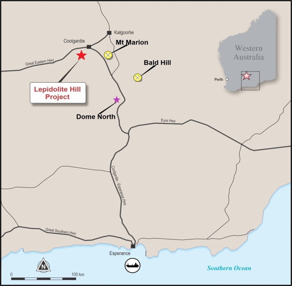
Figure: Project Location
The Project consists of three Prospecting Licenses P15/5574, 5575 and 5739 which are the subject of Mining Lease application 15/1874. The combined area totals 1.07 km2, centered on the shallow lithium mine pit, which is about 150 m long, 60 m wide, and 15 m deep.
Geology
The Project is within the Coolgardie Domain of the Kalgoorlie Terrane that forms part of the Archean Yilgarn Craton. The Coolgardie Domain comprises of an arcuate series of complexly deformed mafic and ultramafic rocks, interbedded with sediments and felsic volcanoclastic rocks. The sequence has been metamorphosed to amphibolite facies and is intruded by felsic porphyry, granite-pegmatite and dolerite dykes. Post-orogenic granite-pegmatites within the district are prospective for lithium, beryl and tantalum- niobium.
The Project covers pegmatite swarms known to contain lepidolite, petalite, tantalite and beryl. Lepidolite is most abundant at Lepidolite Hill, where, in addition to lithium, the mica contains high concentrations of rubidium.
History
The Lepidolite Hill deposit was first discovered in 1944 and named as Lepidolite Hill shortly thereafter. Western Mining Corporation explored the site in 1964, and the deposit was trial mined for lepidolite and petalite from 1971 until 1973.
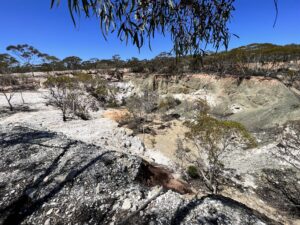
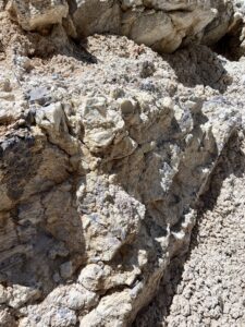
Figure: Lithium Pegmatite exposed in Lepidolite Hill Pit
Historical Works
Exploration Drilling1
In 2019, Lithium Australia drilled a total of 35 reverse circulation (RC) holes for 1135m, within P15/5739, and P15/5574. Hole depths ranged from 12 to 54m. Pegmatite horizons were encountered in all drill holes and visual lepidolite and/or petalite and zinnwaldite were recorded in 19 out of the 35 drill holes, demonstrating that further lithium- bearing pegmatite horizons are present, concealed beneath soil and greenstone lithologies at surface. Drilling also proved that the pegmatite outcrop in the south west (Signal Hill Pegmatite) and the pegmatite outcrop in the old pit (Lepidolite Hill Pegmatite) are in fact one continuous pegmatite.
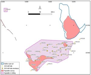
Figure: Drill hole location of Lepidolite Hill, 2019
Table 1: Drill Intersections from Lepidolite Hill, 2019
|
Hole ID |
From (m) |
To (m) |
Intercept (m) |
Ta2O5 ppm |
Li2O % |
Rb2O % |
Cs2O % |
|
LHRC006 |
4 |
8 |
4 |
320 |
0.57 |
0.33 |
0.09 |
|
LHRC010 |
3 |
6 |
3 |
117 |
0.49 |
0.31 |
0.07 |
|
LHRC012 |
28 |
32 |
4 |
2 |
0.55 |
0.04 |
0.02 |
|
LHRC013 |
13 |
18 |
5 |
267 |
1.91 |
1.39 |
0.30 |
|
LHRC014 |
2 |
5 |
3 |
489 |
0.41 |
0.15 |
0.05 |
|
LHRC017 |
6 |
9 |
3 |
131 |
1.12 |
0.72 |
0.16 |
|
LHRC018 |
2 |
5 |
3 |
1248 |
1.13 |
0.57 |
0.21 |
|
LHRC023 |
5 |
23 |
18 |
207 |
1.45 |
1.03 |
0.11 |
|
LHRC024 |
18 |
24 |
6 |
154 |
0.84 |
0.65 |
0.11 |
|
LHRC025 |
6 |
8 |
2 |
285 |
0.67 |
0.32 |
0.09 |
|
LHRC026 |
3 |
13 |
10 |
131 |
1.09 |
0.87 |
0.07 |
|
LHRC030 |
2 |
9 |
7 |
167 |
1.48 |
1.08 |
0.11 |
|
1 WAMEX report: A 122005 F.C. Scholtz dated 2 December 2019 |
Potential
Lepidolite-rich pegmatites are common in the Lepidolite Hill project area. Mine stockpiles and limited drilling has confirmed high grade lithium, tantalum and rubidium. The project area has significant potential for further discoveries of lepidolite, petalite and spodumene.